
The 2022 Cedar Creek Burn & The 1897 Organic Act
By Dr Bob Zybach
December 17, 2024
Source: https://www.oregonfishandwildlifejournal.com
Download .pdf
The 2022 Cedar Creek Fire in Lane County and the Willamette National Forest in western Oregon, burned 127,311 acres. This number included 11,709 acres of so-called "critical habitat" (which the Forest Service calls "CH") for spotted owls ("NSO"), as defined by college professors (PhDs), litigation (EAJA), and the Endangered Species Act (ESA).
Local towns of Oakridge and Westfir were severely threatened by the wildfire, were blanketed with unhealthy smoke for nearly six weeks, and forced to evacuate entirely for four days while power was shut down.
This didn't need to happen. The wildfire was said to have been poorly managed by the Forest Service ("USFS") for an entire month before predictably exploding on an east wind in early September. By the time it was fully extinguished on November 22, taxpayers had spent more than 132 million dollars to employ more than 2500 firefighters that had operated dozens of helicopters and heavy equipment for the previous three months..
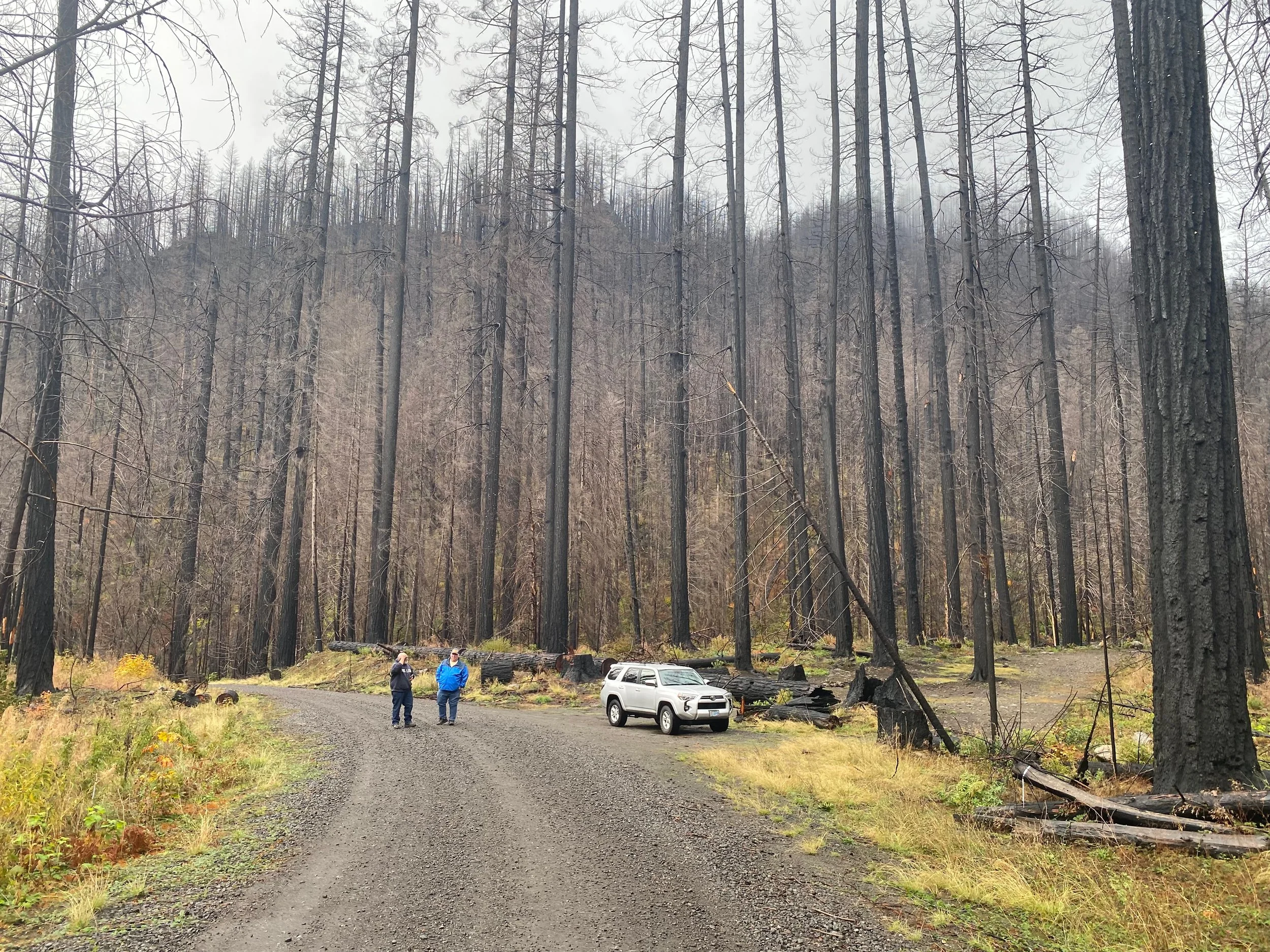
I visited the Cedar Creek Burn a few months ago with three friends, to view the results of two years of Forest Service projects following the fire. We had to get a special permit to pass a locked gate that was installed to keep the public away from the site. That seemed to be it: approximately two billion-plus feet of standing timber, rotting in place, primed to burn again -- only much hotter next time -- no apparent response, and the public is locked out.
The November, 2022 USFS BAER ("Burned Area Emergency Response") report doesn't mention the obviously increased risk of deadly wildfire, but states instead that: "Threats include additional loss of habitat in the fire area due to blowdown, mass soil movement, flooding, and insects and disease." But not wildfire?
Further: "A secondary issue includes determination if the proposed BAER stabilization treatments could affect spotted owl nest sites or result in disruption of nesting if conducted during the critical breeding season from March 1-July 15."
Say what? More than 125,00 acres of trees are dead, nearly 12,000 acres of so-called "CH" has been destroyed, and yet the government can't do anything about it for half the year because of SWO "critical breeding season?" How can this be written, reviewed, and publicly distributed, much less taken seriously?
Speaking in metrics and acronyms and producing voluminous busy-work reports seems to be the effective strategy. Also, the apparent SWO CH "critical breeding period" has apparently now been extended to the entire year, as there was no evidence at all of either USFS or spotted owl occupation at that time -- just a locked gate.
Cedar Creek Fire Timeline
The Cedar Creek Fire started by lightning strikes on August 1, 2022, on the Willamette National Forest, about 15 miles east of the towns of Oakridge and Westfir. According to the BAER report, it couldn't be extinguished as it "grew rapidly" in "inaccessible terrain," and then was "held at control features for around one month" until the east winds arrived -- as generally expected -- in early September.
It is currently unknown why smokejumpers weren't sent to extinguish the fire, but a helicopter with two "rappelers" flew over at 4:45 PM and reported it was about two acres in size and "burning in heavy timber midway up a 40% slope on a significant cliff with limited options for egress."
At that point the rappelers turned down the assignment, reporting the terrain was "too hazardous for safe access." Instead, a plan was developed to hike firefighters into the fire "during the next shift," while helicopters performed bucket drops to limit its growth. The fire was estimated to be about five acres on August 2 and grew to an estimated 500 acres on August 3.
By August 15, the fire had grown to 4,422 acres with 0% containment. All recreational trailheads and dispersed camping were closed both west and north of Waldo Lake. The following day, August 16, the Forest Service posted this statement, along with a three-minute video on its new Facebook public information page:
"Since it started on August 1st, the Cedar Creek Fire has been slowly getting bigger, moving east into wilderness and roadless areas, and south towards the bottom of Cedar and Black Creeks. Hundreds of firefighters have been deployed around the fire, creating primary and backup firelines. This effort is guided by a strategic planning process that combines the latest fire science with on-the ground observations and years of firefighting experience. To learn more about the strategic planning process and why it is being used at Cedar Creek, watch this short video."
On August 27, the fire had grown to 7,632 acres with 0% containment. The "strategic planning process" involved possibly the very first used of USFS "PODs":
"The District identified a contingency line based on a fuels assessment known as PODs (Potential Operational Delineations) well west of the incident. This line would provide a reliable fuel break in the event of a major east wind as well as any future fires that may threaten the communities of Oakridge and Westfir. While fire modeling and seasonality during the early stages of the incident did not indicate a strong likelihood that this line would be utilized, all the teams assigned continued to work on this contingency option."
On September 4 the fire began burning through the 1996 10,400-acre Charlton Burn in the Wilderness along the north side of Waldo Lake. The fire had never been salvaged or treated and was covered with fallen snags that burned very hot and sterilized the soil in much of the area.
By September 8, the fire had grown from 27,000 acres and reached over 73,000 acres according to news sources -- however, the government reported an increase to only 33,000 acres, and growing to 52,000 acres on September 10.
On September 9, the USFS official online information source for wildfires, "InciWeb," reported the "Current Situation" as: "East winds, low humidities, and high temperatures will cause the fire to be active today. The highest activity will occur where lichen is present in trees and there is a high concentration of down wood. Where winds align with slopes, tree canopy fire and fire spotting are anticipated. E winds 15-20; gusts to 50."
Given this report, the Lane County Sherriff's Department made the decision to move Oakridge and Westfir into a "Level 3" evacuation, where residents are asked to leave by a given time and access roads are typically blocked. Powerlines were "de-energized" throughout the wind event and the duration of the evacuations, which were ordered for the following day.
Smoke from the fire moved into southwest Washington on September 10, and Seattle recorded the worst air quality of any major city in the world, with Portland coming in third out of the top 90, and Lahore, Pakistan sandwiched between the two. Seattle's "AQI" was 170 and Portland's was 152 (more on this later).
Sometime at this point the fire began burning into the infamous 1991 Warner Creek Fire scar, which had made national news for several years due to threatened legal actions and active anti-logging protests by "concerned environmentalists."
The 8,973-acre fire had cost $10 million to control and killed an estimated 180 million board feet (mmbf) of timber. Of this amount, only 35 mmbf were scheduled for sale, but two years of protests reduced that number to nine mmbf. Five years of protests and litigation later, no salvage had been completed, and the proposed sales number became only two mmbf. Then, 540,000 board feet were finally sold, and then the sale canceled. In September 2022, it all burned up.
By September 11 the fire had grown to 86,000 acres, more than 2,000 homes had been evacuated, and all highway access to the towns was blocked. Two days later the power was restored, and residents were allowed to return to their homes.
On September 12 the wind had shifted to the northwest and smoke began affecting air quality in Sisters and Bend, while clearing the air in Oakridge for a few days.
On September 16, the Central Oregon Daily News reported the fire had grown to 92,596 acres and videotaped Joan Kluwe, the "Public Information Officer for the Alaska Incident Management Team," saying: "We have 92 engines, 39 crews, 113 types of heavy equipment, and 19 helicopters working on the fire."
The total cost to "fight the fire, maintain and operate the machinery and take care of the personnel" to that date was given as $57,946,000.
On September 25, the fire had grown to 114,104 acres with 20% containment.
By October 27, the fire was 127,283 acres with 60% containment. Due to seasonal dropping temperatures and rising humidity, fire progression had nearly stopped, and the workforce had been reduced to two crews, one helicopter, two masticators. and four engines.
The following day, Fall rains and snow began, and finally, on November 22, the Cedar Creek Fire was declared "out."
1897 Organic Act
In 1897 Congress passed the "Organic Act" to manage and protect US public forestlands. The bill was signed into law by President William McKinley and has never been repealed.
The guiding principal of the Act remains fairly well-known to this time, and has been the theoretical basis to all subsequent USFS planning:
"No public forest reservation shall be established, except to improve and protect the forest within the reservation, or for the purpose of securing favorable conditions of water flows, and to furnish a continuous supply of timber for the use and necessities of citizens of the United States."
A lesser-recognized portion of the Act also states it was "for the purpose of preserving the living and growing timber and promoting the younger growth on forest reservations" -- and, in that regard, authority was given to "designate and appraise so much of the dead, matured, or large growth of trees found upon such forest reservations" for sale at "not less" than the appraised value, under the condition it couldn't be "exported" to another State or Territory.
In a nutshell, "living and growing timber" was intended to be "preserved," "younger growth" was to be "promoted," and a "continuous supply" of "dead, matured, or large" trees were to be sold at market value. "For the use and necessities of citizens of the United States."
In 1905, President Theodore Roosevelt, working closely with Yale-educated forester and close associate, Gifford Pinchot, transferred management of the Forest Reserves from the Department of the Interior to the Department of Agriculture, creating the US Forest Service.
Pinchot became the first Chief of the new agency and wrote that its mission would be: "Where conflicting interests must be reconciled, the question shall always be answered from the standpoint of the greatest good of the greatest number in the long run."
Theoretically, that has remained the mission of the Forest Service to the present time, and all subsequent forest planning laws and regulations are based on this vision and the 1897 Organic Act; including the "expanded purposes" of the 1960 Multiple-Use Sustained-Yield Act (MUSY) and the 1976 National Forest Management Act (NFMA).
The 1960 Act included the considerations of range, water, recreation, and wildlife, along with timber, as renewable resources, and the 1976 Act changed forest planning by requiring the Forest Service to use an "interdisciplinary approach" to resource management -- and to include "public involvement in preparing and revising forest plans."
Local Effects: Smoke & Jobs
Bryan Cutchen is the Mayor of Oakridge, and he says wildfire smoke for the past four years, from the Cedar Creek Fire and others, has done great damage to the town's recreation and hospitality businesses. Others in the community point to the 2015 and 2017 fire years as a major beginning to these events.
The combination of reputation and reality, smoky air, road closures, and burned campgrounds have kept people away from Oakridge in recent years. The discomfort and poor health associated with breathing smoke and the reduced visibility and public access following the fires has caused serious economic damage to the community.
Rob DeHarpport was the third generation of his family to live in Oakridge. His grandfather worked for the Forest Service and his father owned a store in town, and that's where he graduated from High School in 1977 and has lived most of his life. After graduating, he spent a summer fighting fires with the Oakridge Ranger District, and from 2012 to 2015 he became Mayor of Westfir, before retiring and moving east of the Cascades.
During the years he was growing up in town and for many years after, he can only recall a few times when Oakridge became smoky -- typically for a day or two when smoke would drift into town from field burning in the Willamette Valley or from Fall slash pile burning in the woods.
In 1975, when Tim Bailey began his career as a Forester for the Oakridge District Ranger Station, the town had eight gas stations, eight bars, two jewelry stores, two florist shops, a movie theatre, bowling alley, skating rink, and 400 people working at the Pope & Talbot Mill. Today there are three gas stations, up from just one a few years ago and a one-man firewood cutting business.
Bailey's memories are similar to DeHarpport's regarding the general lack of smokey summers and falls. At that time Oakridge considered itself the "Tree Planting Capital of the World" at still has an annual festival to recall those years.
When the 9,000-acre Shady Beach Fire burned in 1988, the 195 mmbf of snags and surviving trees were quickly sold and harvested -- creating an estimated 200 local jobs, and the land was then planted. Today, it is a healthy stand of 35-year-old trees nearing merchantable size.
Bailey wasn't directly involved in the Shady Beach Fire but was the silviculturist for the subsequent Warner Creek Fire. The starkly different histories of the two fires characterized the dramatic change in USFS management philosophies that took place with the arrival of spotted owls in the Douglas Fir Region in 1990.
The Table with this article shows all Air Quality Index (AQI) numbers and PM25 measures for the Oakridge, Eugene, Sisters, and Bend during the smokiest days for those communities during the Cedar Creek Fire. All days that reached an AQI of 100 are listed; those above 200 are bolded; and all above 300 are also made red. The highest PM25 readings for those days are also given, and because Sisters was only impacted for a few days, progressive fire sizes are also listed in that column.
These data were provided by Ryan Porter, who authored the Oregon Department of Environmental Quality (DEQ) report on Oregon statewide air quality for 2022. DEQ AQI numbers are based on a scale of 0-50 (Good); 51-100 (Moderate); 101-150 (Unhealthy for sensitive groups); 151-200 (Unhealthy); 201-300 (Very Unhealthy); and 301-500 (Hazardous).
Compare these numbers to those given earlier for September 10 in Seattle and Portland to better understand the localized severity of this problem.
PM25 numbers represent particulate matters in the air that are 2.5 micrometers or less in diameter. Readings above 35 are considered "unhealthy for short-term exposure," and the National Institute of Health states that "people with respiratory diseases" account for a "large proportion" of "non-accidental deaths" in the US. The stated reason is because PM25 pollution "causes asthma, respiratory inflammation, jeopardizes lung functions, and even promotes cancers."
A recent public health study concluded that more than 10,000 people a year in the US die from wildfire smoke pollution, and recent University of California research indicated PM25 exposure from wildfire smoke likely killed 55,000 Californians alone in the 11 years from 2008 to 2018.
Recommendations
What can be done to fix this deadly, costly mess? It took 35 years for the Willamette National Forest to transform itself from an increasingly unpopular actively-managed clearcutting marketplace to a seasonal inferno, causing massive air pollutions for weeks, killing millions of wildlife and old-growth trees, bankrupting local businesses, ruining the scenery, ending recreation, blocking our public roads with gates, and charging US taxpayers billions of dollars to make it all possible.
Even though significant fault can be found with the design of previous timber sales and reforestation projects, a course correction rather than a complete reversal would have been a more reasonable approach to spotted owl politics. Subsequent planning processes and environmental lawsuits have been allowed, and even encouraged through favorable rulings and legislation, to transform our once beautiful and productive National Forests into ugly, costly, and deadly firebombs. How to fix?
These photos, and millions of others, clearly show the problem. Passively managed conifer forestlands and plantations don't somehow magically transform themselves into "critical habitat" for obscure animals, or into 400-year-old stands of trees teeming with "biodiversity." No, some grow old, they die, and if nothing is done, they burn and are replaced with a new generation of plants, often the same species, but in different configurations.
The real problem began in the 1970s and the deep ecology movement, when the woods became "wildlands" and people were pathogens and the enemies of "nature." Then the academic myth of the "healthy forest" containing "big, dead, standing trees," large logs scattered around on the ground, and a "multi-layered canopy of diverse species" was invented.
To these "New Forestry" ecologists, life appeared to exist in a terrarium, where the ideal was a "non-declining, even-flow, naturally functioning ecosystem" teeming with endangered species and incredible biodiversity. Their computers "proved" this ideal could be achieved "again" -- if only we'd eliminate people, their matches, and their wildlife-disturbing road systems.
Environmental activists, their lawyers, and politicians attempted to transform this fiction into a vision for our public lands, and it has never worked. Instead, death, fire, smoke, and poverty has resulted -- as predicted by actual foresters and knowledgeable residents.
If this fire had happened 40 years ago, in 1982 instead of 2022, many things would have been different. Tens of thousands of fewer acres would have burned; millions more wildlife would have lived; thousands more old-growth would have survived; there would have been only a fraction of the smoke for far fewer days; and the wood would have been immediately salvaged -- and at a profit to local families and to American taxpayers. Then the land would have been reforested as well as possible, based on the best intentions at that time.
A concerted effoThe 2022 Cedar Creek Fire in Lane County and the Willamette National Forest in western Oregon, burned 127,311 acres. This number included 11,709 acres of so-called "critical habitat" (which the Forest Service calls "CH") for spotted owls ("NSO"), as defined by college professors (PhDs), litigation (EAJA), and the Endangered Species Act (ESA).
Local towns of Oakridge and Westfir were severely threatened by the wildfire, were blanketed with unhealthy smoke for nearly six weeks, and forced to evacuate entirely for four days while power was shut down.
This didn't need to happen. The wildfire was said to have been poorly managed by the Forest Service ("USFS") for an entire month before predictably exploding on an east wind in early September. By the time it was fully extinguished on November 22, taxpayers had spent more than 132 million dollars to employ more than 2500 firefighters that had operated dozens of helicopters and heavy equipment for the previous three months..
I visited the Cedar Creek Burn a few months ago with three friends, to view the results of two years of Forest Service projects following the fire. We had to get a special permit to pass a locked gate that was installed to keep the public away from the site. That seemed to be it: approximately two billion-plus feet of standing timber, rotting in place, primed to burn again -- only much hotter next time -- no apparent response, and the public is locked out.
The November, 2022 USFS BAER ("Burned Area Emergency Response") report doesn't mention the obviously increased risk of deadly wildfire, but states instead that: "Threats include additional loss of habitat in the fire area due to blowdown, mass soil movement, flooding, and insects and disease." But not wildfire?
Further: "A secondary issue includes determination if the proposed BAER stabilization treatments could affect spotted owl nest sites or result in disruption of nesting if conducted during the critical breeding season from March 1-July 15."
Say what? More than 125,00 acres of trees are dead, nearly 12,000 acres of so-called "CH" has been destroyed, and yet the government can't do anything about it for half the year because of SWO "critical breeding season?" How can this be written, reviewed, and publicly distributed, much less taken seriously?
Speaking in metrics and acronyms and producing voluminous busy-work reports seems to be the effective strategy. Also, the apparent SWO CH "critical breeding period" has apparently now been extended to the entire year, as there was no evidence at all of either USFS or spotted owl occupation at that time -- just a locked gate.
Cedar Creek Fire Timeline
The Cedar Creek Fire started by lightning strikes on August 1, 2022, on the Willamette National Forest, about 15 miles east of the towns of Oakridge and Westfir. According to the BAER report, it couldn't be extinguished as it "grew rapidly" in "inaccessible terrain," and then was "held at control features for around one month" until the east winds arrived -- as generally expected -- in early September.
It is currently unknown why smokejumpers weren't sent to extinguish the fire, but a helicopter with two "rappelers" flew over at 4:45 PM and reported it was about two acres in size and "burning in heavy timber midway up a 40% slope on a significant cliff with limited options for egress."
At that point the rappelers turned down the assignment, reporting the terrain was "too hazardous for safe access." Instead, a plan was developed to hike firefighters into the fire "during the next shift," while helicopters performed bucket drops to limit its growth. The fire was estimated to be about five acres on August 2 and grew to an estimated 500 acres on August 3.
By August 15, the fire had grown to 4,422 acres with 0% containment. All recreational trailheads and dispersed camping were closed both west and north of Waldo Lake. The following day, August 16, the Forest Service posted this statement, along with a three-minute video on its new Facebook public information page:
"Since it started on August 1st, the Cedar Creek Fire has been slowly getting bigger, moving east into wilderness and roadless areas, and south towards the bottom of Cedar and Black Creeks. Hundreds of firefighters have been deployed around the fire, creating primary and backup firelines. This effort is guided by a strategic planning process that combines the latest fire science with on-the ground observations and years of firefighting experience. To learn more about the strategic planning process and why it is being used at Cedar Creek, watch this short video."
On August 27, the fire had grown to 7,632 acres with 0% containment. The "strategic planning process" involved possibly the very first used of USFS "PODs"
"The District identified a contingency line based on a fuels assessment known as PODs (Potential Operational Delineations) well west of the incident. This line would provide a reliable fuel break in the event of a major east wind as well as any future fires that may threaten the communities of Oakridge and Westfir. While fire modeling and seasonality during the early stages of the incident did not indicate a strong likelihood that this line would be utilized, all the teams assigned continued to work on this contingency option."
On September 4 the fire began burning through the 1996 10,400-acre Charlton Burn in the Wilderness along the north side of Waldo Lake. The fire had never been salvaged or treated and was covered with fallen snags that burned very hot and sterilized the soil in much of the area.
By September 8, the fire had grown from 27,000 acres and reached over 73,000 acres according to news sources -- however, the government reported an increase to only 33,000 acres, and growing to 52,000 acres on September 10.
On September 9, the USFS official online information source for wildfires, "InciWeb," reported the "Current Situation" as: "East winds, low humidities, and high temperatures will cause the fire to be active today. The highest activity will occur where lichen is present in trees and there is a high concentration of down wood. Where winds align with slopes, tree canopy fire and fire spotting are anticipated. E winds 15-20; gusts to 50."
Given this report, the Lane County Sherriff's Department made the decision to move Oakridge and Westfir into a "Level 3" evacuation, where residents are asked to leave by a given time and access roads are typically blocked. Powerlines were "de-energized" throughout the wind event and the duration of the evacuations, which were ordered for the following day.
Smoke from the fire moved into southwest Washington on September 10, and Seattle recorded the worst air quality of any major city in the world, with Portland coming in third out of the top 90, and Lahore, Pakistan sandwiched between the two. Seattle's "AQI" was 170 and Portland's was 152 (more on this later).
Sometime at this point the fire began burning into the infamous 1991 Warner Creek Fire scar, which had made national news for several years due to threatened legal actions and active anti-logging protests by "concerned environmentalists."
The 8,973-acre fire had cost $10 million to control and killed an estimated 180 million board feet (mmbf) of timber. Of this amount, only 35 mmbf were scheduled for sale, but two years of protests reduced that number to nine mmbf. Five years of protests and litigation later, no salvage had been completed, and the proposed sales number became only two mmbf. Then, 540,000 board feet were finally sold, and then the sale canceled. In September 2022, it all burned up.
By September 11 the fire had grown to 86,000 acres, more than 2,000 homes had been evacuated, and all highway access to the towns was blocked. Two days later the power was restored, and residents were allowed to return to their homes.
On September 12 the wind had shifted to the northwest and smoke began affecting air quality in Sisters and Bend, while clearing the air in Oakridge for a few days.
On September 16, the Central Oregon Daily News reported the fire had grown to 92,596 acres and videotaped Joan Kluwe, the "Public Information Officer for the Alaska Incident Management Team," saying: "We have 92 engines, 39 crews, 113 types of heavy equipment, and 19 helicopters working on the fire."
The total cost to "fight the fire, maintain and operate the machinery and take care of the personnel" to that date was given as $57,946,000.
On September 25, the fire had grown to 114,104 acres with 20% containment.
By October 27, the fire was 127,283 acres with 60% containment. Due to seasonal dropping temperatures and rising humidity, fire progression had nearly stopped, and the workforce had been reduced to two crews, one helicopter, two masticators. and four engines.
The following day, Fall rains and snow began, and finally, on November 22, the Cedar Creek Fire was declared "out."
1897 Organic Act
In 1897 Congress passed the "Organic Act" to manage and protect US public forestlands. The bill was signed into law by President William McKinley and has never been repealed.
The guiding principal of the Act remains fairly well-known to this time, and has been the theoretical basis to all subsequent USFS planning:
"No public forest reservation shall be established, except to improve and protect the forest within the reservation, or for the purpose of securing favorable conditions of water flows, and to furnish a continuous supply of timber for the use and necessities of citizens of the United States."
A lesser-recognized portion of the Act also states it was "for the purpose of preserving the living and growing timber and promoting the younger growth on forest reservations" -- and, in that regard, authority was given to "designate and appraise so much of the dead, matured, or large growth of trees found upon such forest reservations" for sale at "not less" than the appraised value, under the condition it couldn't be "exported" to another State or Territory.
In a nutshell, "living and growing timber" was intended to be "preserved," "younger growth" was to be "promoted," and a "continuous supply" of "dead, matured, or large" trees were to be sold at market value. "For the use and necessities of citizens of the United States."
In 1905, President Theodore Roosevelt, working closely with Yale-educated forester and close associate, Gifford Pinchot, transferred management of the Forest Reserves from the Department of the Interior to the Department of Agriculture, creating the US Forest Service.
Pinchot became the first Chief of the new agency and wrote that its mission would be: "Where conflicting interests must be reconciled, the question shall always be answered from the standpoint of the greatest good of the greatest number in the long run."
Theoretically, that has remained the mission of the Forest Service to the present time, and all subsequent forest planning laws and regulations are based on this vision and the 1897 Organic Act; including the "expanded purposes" of the 1960 Multiple-Use Sustained-Yield Act (MUSY) and the 1976 National Forest Management Act (NFMA).
The 1960 Act included the considerations of range, water, recreation, and wildlife, along with timber, as renewable resources, and the 1976 Act changed forest planning by requiring the Forest Service to use an "interdisciplinary approach" to resource management -- and to include "public involvement in preparing and revising forest plans."
Local Effects: Smoke & Jobs
Bryan Cutchen is the Mayor of Oakridge, and he says wildfire smoke for the past four years, from the Cedar Creek Fire and others, has done great damage to the town's recreation and hospitality businesses. Others in the community point to the 2015 and 2017 fire years as a major beginning to these events.
The combination of reputation and reality, smoky air, road closures, and burned campgrounds have kept people away from Oakridge in recent years. The discomfort and poor health associated with breathing smoke and the reduced visibility and public access following the fires has caused serious economic damage to the community.
Rob DeHarpport was the third generation of his family to live in Oakridge. His grandfather worked for the Forest Service and his father owned a store in town, and that's where he graduated from High School in 1977 and has lived most of his life. After graduating, he spent a summer fighting fires with the Oakridge Ranger District, and from 2012 to 2015 he became Mayor of Westfir, before retiring and moving east of the Cascades.
During the years he was growing up in town and for many years after, he can only recall a few times when Oakridge became smoky -- typically for a day or two when smoke would drift into town from field burning in the Willamette Valley or from Fall slash pile burning in the woods.
In 1975, when Tim Bailey began his career as a Forester for the Oakridge District Ranger Station, the town had eight gas stations, eight bars, two jewelry stores, two florist shops, a movie theatre, bowling alley, skating rink, and 400 people working at the Pope & Talbot Mill. Today there are three gas stations, up from just one a few years ago and a one-man firewood cutting business.
Bailey's memories are similar to DeHarpport's regarding the general lack of smokey summers and falls. At that time Oakridge considered itself the "Tree Planting Capital of the World" at still has an annual festival to recall those years.
When the 9,000-acre Shady Beach Fire burned in 1988, the 195 mmbf of snags and surviving trees were quickly sold and harvested -- creating an estimated 200 local jobs, and the land was then planted. Today, it is a healthy stand of 35-year-old trees nearing merchantable size.
Bailey wasn't directly involved in the Shady Beach Fire but was the silviculturist for the subsequent Warner Creek Fire. The starkly different histories of the two fires characterized the dramatic change in USFS management philosophies that took place with the arrival of spotted owls in the Douglas Fir Region in 1990.
The Table with this article shows all Air Quality Index (AQI) numbers and PM25 measures for the Oakridge, Eugene, Sisters, and Bend during the smokiest days for those communities during the Cedar Creek Fire. All days that reached an AQI of 100 are listed; those above 200 are bolded; and all above 300 are also made red. The highest PM25 readings for those days are also given, and because Sisters was only impacted for a few days, progressive fire sizes are also listed in that column.
These data were provided by Ryan Porter, who authored the Oregon Department of Environmental Quality (DEQ) report on Oregon statewide air quality for 2022. DEQ AQI numbers are based on a scale of 0-50 (Good); 51-100 (Moderate); 101-150 (Unhealthy for sensitive groups); 151-200 (Unhealthy); 201-300 (Very Unhealthy); and 301-500 (Hazardous).
Compare these numbers to those given earlier for September 10 in Seattle and Portland to better understand the localized severity of this problem.
PM25 numbers represent particulate matters in the air that are 2.5 micrometers or less in diameter. Readings above 35 are considered "unhealthy for short-term exposure," and the National Institute of Health states that "people with respiratory diseases" account for a "large proportion" of "non-accidental deaths" in the US. The stated reason is because PM25 pollution "causes asthma, respiratory inflammation, jeopardizes lung functions, and even promotes cancers."
A recent public health study concluded that more than 10,000 people a year in the US die from wildfire smoke pollution, and recent University of California research indicated PM25 exposure from wildfire smoke likely killed 55,000 Californians alone in the 11 years from 2008 to 2018.
Recommendations
What can be done to fix this deadly, costly mess? It took 35 years for the Willamette National Forest to transform itself from an increasingly unpopular actively-managed clearcutting marketplace to a seasonal inferno, causing massive air pollutions for weeks, killing millions of wildlife and old-growth trees, bankrupting local businesses, ruining the scenery, ending recreation, blocking our public roads with gates, and charging US taxpayers billions of dollars to make it all possible.
Even though significant fault can be found with the design of previous timber sales and reforestation projects, a course correction rather than a complete reversal would have been a more reasonable approach to spotted owl politics. Subsequent planning processes and environmental lawsuits have been allowed, and even encouraged through favorable rulings and legislation, to transform our once beautiful and productive National Forests into ugly, costly, and deadly firebombs. How to fix?
These photos, and millions of others, clearly show the problem. Passively managed conifer forestlands and plantations don't somehow magically transform themselves into "critical habitat" for obscure animals, or into 400-year-old stands of trees teeming with "biodiversity." No, some grow old, they die, and if nothing is done, they burn and are replaced with a new generation of plants, often the same species, but in different configurations.
The real problem began in the 1970s and the deep ecology movement, when the woods became "wildlands" and people were pathogens and the enemies of "nature." Then the academic myth of the "healthy forest" containing "big, dead, standing trees," large logs scattered around on the ground, and a "multi-layered canopy of diverse species" was invented.
To these "New Forestry" ecologists, life appeared to exist in a terrarium, where the ideal was a "non-declining, even-flow, naturally functioning ecosystem" teeming with endangered species and incredible biodiversity. Their computers "proved" this ideal could be achieved "again" -- if only we'd eliminate people, their matches, and their wildlife-disturbing road systems.
Environmental activists, their lawyers, and politicians attempted to transform this fiction into a vision for our public lands, and it has never worked. Instead, death, fire, smoke, and poverty has resulted -- as predicted by actual foresters and knowledgeable residents.
If this fire had happened 40 years ago, in 1982 instead of 2022, many things would have been different. Tens of thousands of fewer acres would have burned; millions more wildlife would have lived; thousands more old-growth would have survived; there would have been only a fraction of the smoke for far fewer days; and the wood would have been immediately salvaged -- and at a profit to local families and to American taxpayers. Then the land would have been reforested as well as possible, based on the best intentions at that time.
A concerted effort to return to the common sense purposes of the 1897 Organic Act, Pinchot's fundamental mission statement, the 10:00 AM Policy, and the 1962 MUSY would be wonderful. That would be my best recommendation.
This systematic destruction of our public forests and rural communities needs to stop -- and should have been stopped long ago.
A sawmill for plantation and old-growth thinnings and a pellet mill for processing fire-killed trees could be located at the old Pope & Talbot Mill site that Oakridge currently owns. All that would be needed would be a long-term USFS contract, such as established the town of Westfir or the Sustained Yield Units that followed WW II. Even the CCCs from the 1930s could be a model for earning citizenship if modern-day US citizens really won't do "this type of work."
There is much work to be done, it will take thousands of people many years to do it, and it would be a lot cheaper and healthier and far safer and more beautiful, profitable, and productive than what we have now. Or we could keep doing this, and continue to "let nature take her course" and let the lawyers do the expalining.
rt to return to the common sense purposes of the 1897 Organic Act, Pinchot's fundamental mission statement, the 10:00 AM Policy, and the 1962 MUSY would be wonderful. That would be my best recommendation.
This systematic destruction of our public forests and rural communities needs to stop -- and should have been stopped long ago.
A sawmill for plantation and old-growth thinnings and a pellet mill for processing fire-killed trees could be located at the old Pope & Talbot Mill site that Oakridge currently owns. All that would be needed would be a long-term USFS contract, such as established the town of Westfir or the Sustained Yield Units that followed WW II. Even the CCCs from the 1930s could be a model for earning citizenship if modern-day US citizens really won't do "this type of work."
There is much work to be done, it will take thousands of people many years to do it, and it would be a lot cheaper and healthier and far safer and more beautiful, profitable, and productive than what we have now. Or we could keep doing this, and continue to "let nature take her course" and let the lawyers do the expalining.